Credit & Copyright: Landsat 7 Project,
NASA
Explanation:
Launched last month, NASA's
Landsat 7 spacecraft
now orbits planet Earth.
Looking down from an altitude of 700 km,
Landsat 7 can map
the planet's surface in visible and infrared
bands and
resolve features 30 meters across or smaller.
For example,
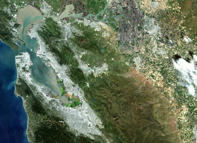
this striking engineering test image is
a natural-looking color composite of 3 different
visible wavelength bands.
It nicely shows details of urban areas around San Francisco,
California, USA,
nestled in the surrounding terrain (north is up).
Flowing blue-green
colors track the spring runoff from
the Sierras to the west and neighboring mountains into
the bay and out into the Pacific ocean.
Landsat 7 is
currently performing well in its check out phase
and controllers are preparing the satellite for
regular operations.
1999 2000 2001 2002 2003 2004 2005 2006 2007 2008 2009 2010 2011 2012 2013 2014 2015 2016 2017 2018 2019 2020 2021 2022 2023 2024 2025 2026 |
Yanvar' Fevral' Mart Aprel' Mai Iyun' Iyul' Avgust Sentyabr' Oktyabr' Noyabr' Dekabr' |
NASA Web Site Statements, Warnings, and Disclaimers
NASA Official: Jay Norris. Specific rights apply.
A service of: LHEA at NASA / GSFC
& Michigan Tech. U.
|
Publikacii s klyuchevymi slovami:
Earth - planet - landsat - san fransisco - ISZ - Sputniki iskusstvennye
Publikacii so slovami: Earth - planet - landsat - san fransisco - ISZ - Sputniki iskusstvennye | |
Sm. takzhe:
Vse publikacii na tu zhe temu >> | |
