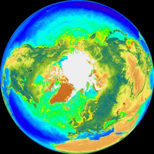
Explanation: The Sea-viewing Wide Field-of-view Sensor (SeaWiFS) instrument onboard the orbiting SeaStar spacecraft can map subtle differences in Earth's ocean color. These North (left) and South Pole projections are based on SeaWiFS measurements made between September 1997 and July 1998. The "color" strongly depends on how sunlight is reflected by free-floating phytoplankton - photosynthesizing organisms which contain chlorophyll. Chlorophyll absorbs blue and red light and reflects green. Since the tiny phytoplankton are tremendously important, forming the beginning of the food chain for sea life, SeaWiFS color maps can help track the activity of ocean planet Earth's biosphere.
1999 2000 2001 2002 2003 2004 2005 2006 2007 2008 2009 2010 2011 2012 2013 2014 2015 2016 2017 2018 2019 2020 2021 2022 2023 2024 2025 |
Yanvar' Fevral' Mart Aprel' Mai Iyun' Iyul' Avgust Sentyabr' Oktyabr' Noyabr' Dekabr' |
NASA Web Site Statements, Warnings, and Disclaimers
NASA Official: Jay Norris. Specific rights apply.
A service of: LHEA at NASA / GSFC
& Michigan Tech. U.
|
Publikacii s klyuchevymi slovami:
Earth - ocean - north pole - south pole - Zemlya - okean - biosfera
Publikacii so slovami: Earth - ocean - north pole - south pole - Zemlya - okean - biosfera | |
Sm. takzhe:
Vse publikacii na tu zhe temu >> | |
