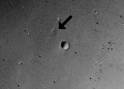
Credit & Copyright: Viking
1 Orbiter Team
Explanation:
Where is
Mars Pathfinder?
Follow the arrow in the above picture taken by the
Viking Orbiter
in 1976. From the
surface Mars appears covered with rocks,
but from
orbit Mars appears covered with craters.
However, several familiar features are visible in
this photograph.
To the left (west) of
Sagan Memorial Station
are the now-familiar
twin peaks
that dominate the horizon of
many Pathfinder photographs.
These hills are about one kilometer from the landing site, twice the planned range
of
Sojourner.
Two craters loom nearby: a small one to the east not easily visible here,
and a big one to the south of Pathfinder.
The landing site is in the dry flood channel named
Ares Vallis.
1999 2000 2001 2002 2003 2004 2005 2006 2007 2008 2009 2010 2011 2012 2013 2014 2015 2016 2017 2018 2019 2020 2021 2022 2023 2024 2025 2026 |
Yanvar' Fevral' Mart Aprel' Mai Iyun' Iyul' Avgust Sentyabr' Oktyabr' Noyabr' Dekabr' |
NASA Web Site Statements, Warnings, and Disclaimers
NASA Official: Jay Norris. Specific rights apply.
A service of: LHEA at NASA / GSFC
& Michigan Tech. U.
|
Publikacii s klyuchevymi slovami:
Mars pathfinder - Mars - poverhnost' Marsa - Viking
Publikacii so slovami: Mars pathfinder - Mars - poverhnost' Marsa - Viking | |
Sm. takzhe:
Vse publikacii na tu zhe temu >> | |
