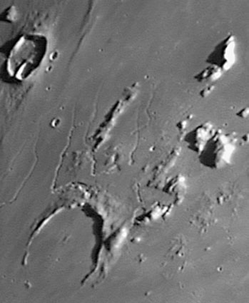
Well, it actually still is known as Prinz. I can't say much about the crater itself - its a 47 km wide crater with a completely mare-flooded interior. The north rim of the crater rises a kilometer above the mare surface, but most of the southern rim is gone. Where did it go? The fact that the rim height smoothly decreases from north to south suggests that the crater either formed on a slope or, more likely, the terrain to the south subsided after Prinz formed. But I don't know why the south would subside, so perhaps the north has been uplifted. According to the topo contours in the Times Atlas of the Moon the high spot of this area is just north of Prinz, which is the source area for sinuous rilles beautifully captured in K.C. Pau's image. Rilles flow downslope, providing further evidence that the area immediately north of Prinz is high. I speculate that the magma that rose near the surface to feed the rilles also domed up the north side of Prinz. Piling speculation on speculation, the uplift also brought up portions of the rim of the Imbrium basin, which are the peaks visible on the upper right side of the image - the Harbinger Mountains! Maybe the Prinz uplift is a smaller and less structured version of the nearby Aristarchus Plateau uplift.
Technical Details:
May 1, 2004. 10" f/6 Newtonian + 5X Barlow + Phillips Toucam Pro; 114 stacked frames.
Related Links:
Apollo 15 View
|
Yanvar' Fevral' Mart Aprel' Mai Iyun' Iyul' Avgust Sentyabr' Oktyabr' Noyabr' Dekabr' |
|
Publikacii s klyuchevymi slovami:
Moon - Luna - Lunar Photo of the Day - LPOD
Publikacii so slovami: Moon - Luna - Lunar Photo of the Day - LPOD | |
Sm. takzhe:
Vse publikacii na tu zhe temu >> | |
