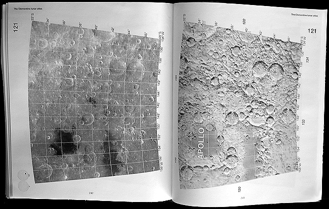
Finally, after much waiting, the Clementine Atlas of the Moon by Ben Bussey and Paul Spudis has arrived from England and is being mailed to early buyers. Unfortunately for me, my copy was seriously damaged so now I await a new one. But if you have only seen the cover, here is a sample two page spread. On the left is a mosaic of Clementine images, and the right shows the same area using the US Geologic Survey airbrushed shaded relief map. These particular pages show the area of Apollo, a multi-ring impact basin on the lunar farside. All named and lettered craters are clearly identified, although names of ridges and some other features are not included. Each image/map pair shows a 16 degree swath of latitude (about 480 km), with a grid of lat/long lines spaced every two degrees. The Clementine mosaics have low enough sun angles between about 50 degree latitude and the poles for crater morphology to be pretty well displayed; between 50 degrees and the equator the Sun angle is higher and albedo features are most conspicuous. The quality of reproduction is good enough to use the Clementine images for research - for example, searching for and cataloging ray craters - both bright and dark halo ones. See the small but bright ray crater on sheet 72 for an example. This is not an atlas for use at the telescope, and its variable Sun angle means you can't always get the view you want, but this 144 sheet atlas will be a mandatory purchase for serious students of the Moon.
Related Links:
Yahoo Price Comparison
|
Yanvar' Fevral' Mart Aprel' Mai Iyun' Iyul' Avgust Sentyabr' Oktyabr' Noyabr' Dekabr' |
|
Publikacii s klyuchevymi slovami:
Moon - Luna - Lunar Photo of the Day - LPOD
Publikacii so slovami: Moon - Luna - Lunar Photo of the Day - LPOD | |
Sm. takzhe:
Vse publikacii na tu zhe temu >> | |
