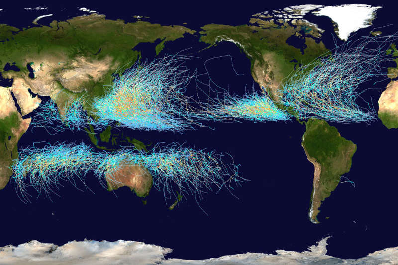
Explanation: Where on Earth do cyclones go? Known as hurricanes when in the Atlantic Ocean and typhoons when in the Pacific, the featured map shows the path of all major storms from 1985 through 2005. The map shows graphically that cyclones usually occur over water, which makes sense since evaporating warm water gives them energy. The map also shows that cyclones never cross -- and rarely approach -- the Earth's equator, since the Coriolis effect goes to zero there, and cyclones need the Coriolis force to circulate. The Coriolis force also causes cyclone paths to arc away from the equator. Although long-term trends remain a topic of research, evidence indicates that hurricanes have become, on the average, more powerful in the North Atlantic over the past 30 years, and their power is projected to keep increasing.
Follow APOD on Instagram in:
English,
Farsi,
Indonesian,
Persian, or
Portuguese
1999 2000 2001 2002 2003 2004 2005 2006 2007 2008 2009 2010 2011 2012 2013 2014 2015 2016 2017 2018 2019 2020 2021 2022 2023 2024 2025 |
Yanvar' Fevral' Mart Aprel' Mai Iyun' Iyul' Avgust Sentyabr' Oktyabr' Noyabr' Dekabr' |
NASA Web Site Statements, Warnings, and Disclaimers
NASA Official: Jay Norris. Specific rights apply.
A service of: LHEA at NASA / GSFC
& Michigan Tech. U.
|
Publikacii s klyuchevymi slovami:
Earth - storm - Zemlya - uragan
Publikacii so slovami: Earth - storm - Zemlya - uragan | |
Sm. takzhe:
Vse publikacii na tu zhe temu >> | |
