|
Credit & Copyright: Mars Global Surveyor Project,
NASA
Explanation:
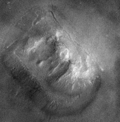
Yesterday the Mars Global Surveyor project
released a new close-up image
of a portion of the Cydonia region on Mars.
This cropped and processed version
shows an area about 2 miles wide (the
full version covers a strip nearly 2.6 miles wide by 25 miles long)
and at full resolution has a pixel size of about 14 feet.
The rock formation visible is
the famous feature seen as
the "Face on Mars"
in 1976 Viking orbiter images.
Such complex looking
landforms in the Cydonia region are thought to be the result of
erosion and weathering of ancient crust by Martian winds, frost,
and possibly surface water.
Mars Global Surveyor
is scheduled to take other images of the Cydonia region
and the Mars Pathfinder and Viking landing sites this month.
|
January February March April May June July August September October November December |
| ||||||||||||||||||||||||||||||||||||||||||||||||
NASA Web Site Statements, Warnings, and Disclaimers
NASA Official: Jay Norris. Specific rights apply.
A service of: LHEA at NASA / GSFC
& Michigan Tech. U.
Based on Astronomy Picture
Of the Day
Publications with keywords: Mars - face - surface - cydonia region
Publications with words: Mars - face - surface - cydonia region
See also:
- APOD: 2025 September 28 B Leopard Spots on Martian Rocks
- APOD: 2025 July 15 B Collapse in Hebes Chasma on Mars
- APOD: 2025 July 6 B The Spiral North Pole of Mars
- APOD: 2025 June 29 B Dark Sand Cascades on Mars
- APOD: 2025 June 22 B A Berry Bowl of Martian Spherules
- APOD: 2025 June 15 B Two Worlds One Sun
- Perseverance Selfie with Ingenuity
